the Creative Commons Attribution 4.0 License.
the Creative Commons Attribution 4.0 License.
 | 11 Apr 2024
Urban roadkill assessment in Vienna reveals low incidence rates
Susanne Lutter
Irene Hoppe
Johann G. Zaller
Daniel Dörler
An important factor in the decline of global animal diversity is road traffic, where many animals are killed. This study aimed to collect data on vertebrate roadkill in the city of Vienna, Austria, between 2017 and 2022 using three different approaches: citizen science, systematic monitoring by bicycle along a 15 km route, and systematic monitoring on foot along a 3 km route. During 359 monitoring events, only four roadkill incidences (three Erinaceus sp., one Rattus sp.) were found by bicycle or on foot. At the same time citizen scientists reported 1 roadkill squirrel on the bicycle route and 84 roadkill incidences for the entire city area. Hedgehogs and urban birds were commonly reported species by citizen scientists. Although no amphibian or reptile roadkill was found during systematic monitoring, they were reported by citizen scientists. The low number of roadkill incidences found suggests a potentially low population density that makes the impact of roadkill even more severe – a hypothesis that should be further investigated amidst the global decline in biodiversity.
- Article
(2422 KB) - Full-text XML
- BibTeX
- EndNote


Along with climate change, the decline in global biodiversity is one of the central challenges facing humanity (IPBES, 2019). Numerous drivers, including the decline and degradation of habitats, are leading to the loss of many animal and plant species. A direct human influence on the reduction of animal populations is roadkill, i.e. animals killed by road traffic (Schwartz et al., 2020; Heigl et al., 2017, 2016). A recent review of the demographic impact of roadkill on mammal populations revealed a large variability, ranging from 1.1 % to 80 % of roadkill as a proportion of total mortality (Moore et al., 2023). Citizen science projects in Great Britain, California, Belgium, Italy, and Taiwan show that animals are also roadkill in urban areas (Programs – Global Roadkill Network, 2023). However, whether urban areas increase or decrease the number of roadkill incidents depends very much on the animal species and the surrounding landscape. Foxes and badgers seem to be roadkill less often in urban areas and hedgehogs more often (Gunson et al., 2011; Kent et al., 2021). In Great Britain, the probability of hedgehog roadkill appears to be associated with urban and suburban environments based on data from multiple sources, including citizen science and systematic monitoring scheme programmes (Wright et al., 2020). In Campania (Italy), citizen science data on roadkill animals revealed a positive association between roadkill of certain species (e.g. the European hedgehog) and urban areas (Valerio et al., 2021). However, studies on regular monitoring of roadkill in urban areas in Europe are rare. Łopucki et al. (2021) monitored hedgehog roadkill on seven 1.2 km road sections in a city in Poland for 3 years and found on average 5.4±2.1 and 4.9±1.1 hedgehog roadkill incidents in 2018 and 2019, respectively. Monitoring a 98 km stretch of road by bicycle in a rural region in eastern Austria over 20 months reported 252 roadkill amphibians and reptiles (0.05 roadkill incidences per km d−1; Heigl et al., 2017). Gálvez (2021) monitored a 12 km road segment next to the Panama Canal in a landscape dominated by the rainforest and suburban areas and found 79 roadkill vertebrates in 36 months (0.006 roadkill incidents per km d−1). Santos et al. (2022) monitored on average every 43 d a 244 km road stretch in a transition zone between the Amazonia and Cerrado in Mato Grosso, Brazil, for 34 months and found 1005 vertebrate roadkill incidents (0.16 roadkill incidents per km d−1). Delgado et al. (2019) monitored up to 16 km rural asphalt roads in Spain by foot twice in two seasons and found 396 roadkill animals from 67 species (0.25 roadkill incidents per km d−1). These studies show significant variability in roadkill incidents per road kilometre, depending on the geographical area and methodology employed. The aim of our study was to collect data on roadkill vertebrates in Vienna applying three methods: citizen science, monitoring by bicycle, and monitoring by foot. Monitoring routes were selected based on previous citizen science roadkill reports, landscape variables for high probabilities of vertebrate habitats, and degree of motorisation. The study did not aim to directly compare the methods in terms of efficiency. Based on previous studies we anticipated that all three approaches should result in a dataset that can be used for identifying roadkill hotspots and landscape influences.
2.1 Study area
The monitoring routes are located in the city of Vienna, Austria. Vienna has a population of about 2.0 million inhabitants and is located in the north-east of Austria on the eastern edge of the European Alps, covering an altitude of 151–543 m a.s.l. (Fig. 1). The city has a total area of 414.87 km2 and an extensive road network of 2793 km, resulting in a road surface area of 23.64 km2 (5.7 % of the total area of Vienna (Zahlen und Fakten zum Wiener Straßennetz, 2023). Vienna is situated in a transition zone between oceanic climate influences from the west and continental climate influences from the east, with an average rainfall of 550 mm yr−1. Vienna is surrounded by the Viennese forest in the west, the agricultural plains of the Marchfeld to the northeast, the floodplains of the Lobau to the east, and the Vienna Basin to the south. Green areas such as forests, agricultural areas, or parks make up 45 % of the city area, 36 % building areas, 15 % traffic areas (e.g. roads, railway tracks), and the remaining 5 % of the area water bodies. The percentage of green area varies between 2 % and 15 % in the inner districts near the city centre and can reach up to 70 % in the districts at the fringe of the city (Wieser, 2022).
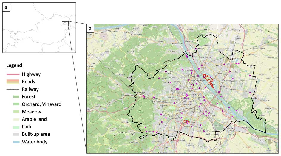
Figure 1Location of the study area. Vienna is located in the north-east of Austria (a, made with Natural Earth. Free vector and raster map https://www.naturalearthdata.com/downloads/10m-cultural-vectors/, last access: 21 July 2021). Pink: location of reports of roadkill by citizen scientists and by our monitoring within the borders of the city of Vienna. Red: monitoring routes of the current study (b, © OpenStreetMap contributors 2023. Distributed under the Open Data Commons Open Database License (ODbL) v1.0.).
For the current study, we selected two monitoring routes for the current investigation (Fig. 1), based on three factors: (1) number of previously reported roadkill incidents in the citizen science project Roadkill, (2) suitable habitats for various vertebrates, and (3) degree of motorisation. The northern route (districts 21 and 22) was monitored by a graduate student by bike and was 12 km long. Two roadkill incidents (1 hedgehog and 1 Anuran) were reported directly on the monitoring route and two roadkill incidents (1 bird and 1 hedgehog) in a 200 m buffer around the route via the citizen science project Roadkill in the years prior to the monitoring effort (https://roadkill.at/en/, last access: 5 February 2022). The number of roadkill reports on and near the two monitoring routes prior to the monitoring effort were similar to reports on other roads in the City of Vienna and therefore could be considered representative. Compared to other districts in Vienna, district 22 has a very high degree of motorisation with 11.66 % of all motorised vehicles registered in Vienna and 3.43 % of the road surface area. Besides the recreational area Donaupark (633 000 m2) and private gardens, many other landscape types could be found along the route: road space, railway facilities, parks, forests, meadows, agricultural landscape, water bodies, and built-up spaces (e.g. private houses; Fig. 2a).
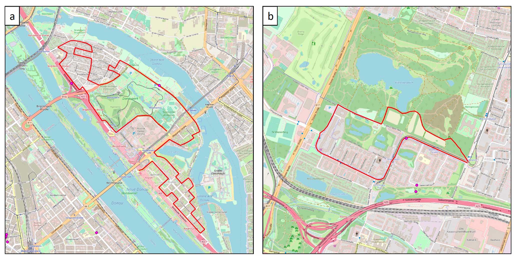
Figure 2Surrounding landscape of the northern monitoring route (a) and the southern monitoring route both marked in red (b; © OpenStreetMap contributors 2023. Distributed under the Open Data Commons Open Database License (ODbL) v1.0.). The legend of the land use classes can be found in Fig. 1.
The southern route (district 10) was monitored on foot by a citizen scientist and was 3 km long. Four roadkill incidents (1 hedgehog and 3 smooth newts, Lissotriton vulgaris) were reported directly on the monitoring route. Three roadkill incidents (3 Lissotriton vulgaris) were reported previously in a 200 m buffer around the route via citizen science. Along the route is the recreational area Wienerberg (1 230 000 m2) with water bodies, meadows, forests, road spaces, railway facilities, other traffic areas such as parking spaces, and built-up areas (e.g. community buildings). Furthermore, the city motorway A23 runs south of the route; however noise barriers separate it from the residential areas (Fig. 2b). With 9.42 % of all motorised vehicles registered in Vienna, the 10th district has the second highest level of motorisation (Kraftfahrzeugbestand nach Gemeindebezirken 2019 – Offizielle Statistik der Stadt Wien, 2023). The proportion of road surface area in the district is 6 %.
Leveraging open-access data from the Global Biodiversity Information Facility (GBIF, https://www.gbif.org/, last access: 26 January 2024) has revealed a total of 77 867 reported vertebrates in Vienna since the year 2000. Bird species (class Aves) dominate with 73 062 individuals, with Corvus cornix (5884 ind.), Parus major (5249 ind.), and Turdus merula (3948 ind.) being the most frequently reported species. Mammal species (class Mammalia) follow with 2113 individuals, with Sciurus vulgaris (750 ind.), Cricetus cricetus (357 ind.), and Capreolus capreolus and Castor fiber (163 ind. each) as the leading species. Amphibians (class Amphibia) contribute 1457 records, with Salamandra salamandra (567 ind.), Bufo bufo (215 ind.), and Rana dalmatina (124 ind.) being the most reported species. Of reptiles (class Squamata), 722 records exist, with Zamenis longissimus (148 ind.), Natrix natrix (140 ind.), and Anguis fragilis (135,ind.) as the predominantly reported species. Analysis of the GBIF data suggests that Vienna harbours a diverse array of vertebrate species, encompassing both common and rare taxa, exemplified by the presence of the European hamster (C. cricetus). Unfortunately, no comprehensive species lists were available for the immediate surrounding landscape of the monitoring routes. Considering the large home ranges of frequently documented species, such as birds, squirrels, common toads, and Aesculapian snakes, surpassing road densities, we assumed that these species were likely to be encountered as roadkill during monitoring activities. Due to the combination of already reported roadkill, suitable habitats for different vertebrate species and the high level of motorisation in the area, we expected that a large number of roadkill incidences would be found during monitoring.
2.2 Data collection
The northern route was monitored by bicycle for 1 month in autumn 2017 (18 October to 17 November 2017) and spring 2018 (27 March to 26 April 2018) with an average speed of 15 km h−1. During both periods, the same route was checked for vertebrate roadkill between 08:00 and 12:00 CET in both directions of travel on road traffic routes as well as directly in the marginal area of the road almost every day (with the exception of 5 d).
The monitoring of the southern route was carried out on foot from 2 February 2020 to 30 January 2022 on average every 2.41 d (302 visits in 729 d).
Roadkill incidents reported by citizen scientists via the Roadkill app were extracted for the same time periods as the monitoring periods were conducted within the city borders of Vienna (https://roadkill.at/en/, last access: 5 February 2022).
During the monitoring periods, three hedgehogs (Erinaceus sp.) were found on the northern route by bicycle (0.004 roadkill incidents per km d−1) and one rat (Rattus sp.) on the southern route by foot (0.001 roadkill incidents per km d−1).
During the same periods, 45 citizen scientists reported 84 roadkill incidents within the city borders of Vienna via the citizen science project Roadkill (Fig. 1), including one squirrel (Sciurus vulgaris) reported on the northern route. Citizen scientists reported roadkill incidents when travelling by car (38 reports), by foot (28 reports), and by bike (18 reports). The most often reported mammal species by citizen scientists were hedgehogs (Erinaceus sp., 18), followed by red squirrels (Sciurus vulgaris, 8) and European hare (Lepus europaeus, 3). Among birds, street pigeons (Columba livia domestica, 8) were reported most frequently, followed by buzzards (Buteo buteo, 2). The most frequently reported amphibians and reptiles were the dice snake (Natrix tessellata, 6), the grass snake (Natrix natrix, 3), and the common toad (Bufo bufo, 2).
Our results provide insights into the severity of roadkill in Vienna. A first glance at the map in Fig. 1 reveals that although 84 roadkill incidents were reported as part of the citizen science project, only 4 roadkill incidents were found on the monitoring routes defined for the current study, even though these routes were selected based on previously reported roadkill, suitable habitats, and degree of motorisation in the surroundings.
Assuming that the reports by citizen science are random and the number of undetected roadkill is very high, one would expect that regular monitoring would lead to more roadkill reports, regardless of where in the city the routes are located. However, given the heterogeneity of a city, habitat suitability, road density, and traffic volume influence the occurrence of roadkill (Beninde et al., 2015). Moreover, the number of roadkill incidents cannot be explained by urbanity alone, but rather by species abundance (Kent et al., 2021). The most frequently reported roadkill species were mostly located on roads surrounded by species-typical habitats, confirming the results of Kent et al. (2021). For example, roadkill hedgehogs were predominantly found on roads adjacent to parks or gardens, hares were frequently sighted near agricultural areas, and dice snakes were often encountered near water bodies.
The most frequently reported animal species on GBIF since 2000 do not match the most frequently reported roadkill. This could be explained by the reporting behaviour of citizen scientists (Mair and Ruete, 2016). Hedgehogs, for example, are nocturnal and are therefore very rarely observed alive, but roadkill hedgehogs are very often reported. Pigeons, on the other hand, are perceived as omnipresent in the city and are therefore rarely reported. This pattern is also reflected in the GBIF data on reported bird species in Vienna.
Surrounding land cover has a major influence on the number of roadkill incidents (Valerio et al., 2021; Heigl et al., 2017). Our monitoring routes were located near large parks as well as near water bodies and single-family houses with gardens. The most frequently reported mammal species in our monitoring and also by citizen scientists were hedgehogs (Erinaceus sp.). Red squirrels (Sciurus vulgaris) were the second most frequently reported species from citizen scientists. Both species are characteristic inhabitants of residential areas, including gardens, parks, hedges, and grasslands. Hedgehogs, well-documented as the most prevalent mammals in various roadkill studies, live predominantly in urban and suburban landscapes (Tajchman et al., 2020; Wright et al., 2020; Łopucki et al., 2021). Surprisingly, three hedgehogs were found on one of our monitoring routes, while not a single hedgehog was found on the other monitoring route. A possible reason for this difference could be that the park next to the southern route is twice as large as the park next to the northern route and provides a more suitable habitat for hedgehogs. Therefore, hedgehogs are probably not forced to leave the park and cross roads, for example, for foraging. The most frequently reported bird species (pigeons Columba livia domestica and buzzards Buteo buteo) are typical species of urban and suburban environments (Przybylska et al., 2012). Pigeons utilise buildings for breeding, while buzzards build their nests in park treetops, where they prey on the city's abundant small-mammal population (Dietrich and Otto, 2011). Pigeons are often roadkill while feeding on roads, mirroring the vulnerability of B. buteo as they feed on the remains of roadkill. However, the two roadkill B. buteo were both reported by citizen scientists on the outskirts of Vienna surrounded by agricultural area.
It has been shown that animals avoid roads in cities due to the high traffic density or the lack of suitable habitats. Additionally, lower traffic speeds in cities can also result in less roadkill. As our monitoring sites were situated in the two districts exhibiting the highest motorisation rates, the results could suggest that there are barrier effects. The relatively low proportion of road surface area would also support this assumption, as traffic might be concentrated on a few roads. Unfortunately, we lack data on traffic density along the monitoring routes to validate this hypothesis. However, vertebrate species respond very differently to traffic volumes, which can lead to either avoidance or to higher roadkill rates (Jacobson et al., 2016; Oddone Aquino and Nkomo, 2021). The animal species most frequently reported by citizen scientists were hedgehogs, red squirrel, street pigeons, and dice snakes. Each of these animal species responds differently to traffic density. It seems that hedgehogs do not regard a road with elevated traffic levels as a barrier, as the incidence of roadkill appears to escalate with higher traffic density (Huijser and Bergers, 2000; Sadleir and Linklater, 2016). Squirrels also do not appear to consider roads with low or high traffic as barriers (Fey et al., 2016). On the other hand, street pigeons seem to avoid high road densities and urban areas with low-rise buildings and are more abundant in city centres (Przybylska et al., 2012). Mészáros et al. (2023) conclude that urban areas could provide a suitable habitat for dice snakes but that populations living in areas with higher road density showed more asymmetric traits. Our monitoring routes covered only a small fraction of the road network in Vienna, with mostly side streets and roads with a speed limit up to 50 km h−1. The percentage of road area in the two districts ranges from 3.43 %–5.97 %, representing a rather suburban character. Vienna's road network is very diverse and ranges from small side streets where cars drive at walking speed to city motorways with a speed limit of 80 km h−1. Hence, extrapolation from our monitored sites to the entire city of Vienna is not meaningful. Nonetheless, the findings from citizen science reports suggest that the majority of roadkill incidents in Vienna are animals that occur relatively frequently and do not perceive roads as barriers, irrespective of the traffic volume. This raises concerns that roadkill could have a disproportionate impact on the populations of these common animals. This possible influence on the population density of common animal species should be investigated in more detail in the future.
Another reason why relatively few roadkill incidents were found during this period could have been the Covid-19 pandemic, which fell in the second monitoring period. During this time, people were generally travelling less and the reduced road traffic also led to a lower number of roadkill incidents (Dörler and Heigl, 2021; Bíl et al., 2021). To summarise, the low rates of roadkill reports can be the result of many reasons. Two important possibilities could be that the roads are strong barriers and thus cannot be crossed by animals or that past vehicle collisions have already led to a severe reduction in populations (Ascensão et al., 2019). As most of the species reported by citizen science are species that do not consider roads as barriers, the second possibility seems more reasonable.
The fact that no amphibians and reptiles were found during monitoring, but were found through citizen science, could be due to the frequency of monitoring. Small animals in particular do not remain on the road as roadkill for long, as they are quickly consumed or cut up by road traffic, so they are often only found through daily monitoring or by chance (Santos et al., 2011; Schwartz et al., 2018). Due to a lack of data on the population dynamics of the identified vertebrate species, we cannot draw definitive conclusions about the impact of roads on these animal species from our findings. Additionally, our results do not support the claim that the roads within the study area are inherently safe for vertebrates, as there are few observed roadkill incidents. It is plausible that the low incidence of roadkill is also due to inherently low population densities.
Our study is one of the few that has investigated roadkill in cities. Surprisingly, all three approaches (citizen science, monitoring by bicycle, and monitoring on foot) resulted in very few roadkill reports. Since the citizen science reports come from relatively few people and the monitoring routes only represent a small part of the Vienna road network, we suggest to make the citizen science approach more widely known in Vienna and to start monitoring the population dynamics of common roadkill species in order to be able to make generalisable conclusions about the impact of roads on vertebrates in Vienna.
All data used for the article were collected with apps from the citizen science project Roadkill. Data from project Roadkill are available on GBIF and Zenodo (Heigl et al., 2022).
FH, DD, and JGZ designed the study. FH prepared the article with the help of all authors. IH and SL conducted the monitoring.
The contact author has declared that none of the authors has any competing interests.
Publisher’s note: Copernicus Publications remains neutral with regard to jurisdictional claims made in the text, published maps, institutional affiliations, or any other geographical representation in this paper. While Copernicus Publications makes every effort to include appropriate place names, the final responsibility lies with the authors.
We thank all the citizen scientists who reported the data and helped identify the species. Without the many volunteer efforts of the citizen scientists, the research presented in this article would not have been possible. We acknowledge the use of the AI language model provided by OpenAI for assistance in generating the title and improving the abstract of the article.
This paper was edited by Sonja Knapp and reviewed by two anonymous referees.
Ascensão, F., Kindel, A., Teixeira, F. Z., Barrientos, R., D'Amico, M., Borda-de-Água, L., and Pereira, H. M.: Beware that the lack of wildlife mortality records can mask a serious impact of linear infrastructures, Global Ecol. Conserv., 19, e00661, https://doi.org/10.1016/j.gecco.2019.e00661, 2019.
Beninde, J., Veith, M., and Hochkirch, A.: Biodiversity in cities needs space: a meta-analysis of factors determining intra-urban biodiversity variation, Ecol. Lett., 18, 581–592, https://doi.org/10.1111/ele.12427, 2015.
Bíl, M., Andrášik, R., Cícha, V., Arnon, A., Kruuse, M., Langbein, J., Náhlik, A., Niemi, M., Pokorny, B., Colino-Rabanal, V. J., Rolandsen, C. M., and Seiler, A.: COVID-19 related travel restrictions prevented numerous wildlife deaths on roads: A comparative analysis of results from 11 countries, Biol. Conserv., 256, 109076, https://doi.org/10.1016/j.biocon.2021.109076, 2021.
Delgado, J. D., Durán Humia, J., Rodríguez Pereiras, A., Rosal, A., del Valle Palenzuela, M., Morelli, F., Arroyo Hernández, N. L., and Rodríguez Sánchez, J.: The spatial distribution of animal casualties within a road corridor: Implications for roadkill monitoring in the southern Iberian rangelands, Transport. Res. D-Tr. E., 67, 119–130, https://doi.org/10.1016/j.trd.2018.11.017, 2019.
Dietrich, R. and Otto, W.: Bestand und Reproduktion des Mäusebussards Buteo buteo im Osten Berlins 2000–2011, Berliner ornithologischer Bericht, 21, 1–15, http://orniberlin.de/images/stories/BOB_pdf/BOB_21_Maeusebussard.pdf (last access: 25 January 2024), 2011.
Dörler, D. and Heigl, F.: A decrease in reports on road-killed animals based on citizen science during COVID-19 lockdown, PeerJ, 9, e12464, https://doi.org/10.7717/peerj.12464, 2021.
Fey, K., Hämäläinen, S., and Selonen, V.: Roads are no barrier for dispersing red squirrels in an urban environment, Behav. Ecol., 27, 741–747, https://doi.org/10.1093/beheco/arv215, 2016.
Gálvez, D.: Three-year monitoring of roadkill trend in a road adjacent to a national park in Panama, Biotropica, 53, 1270–1275, https://doi.org/10.1111/btp.12995, 2021.
Gunson, K. E., Mountrakis, G., and Quackenbush, L. J.: Spatial wildlife-vehicle collision models: A review of current work and its application to transportation mitigation projects, J. Environ. Manage., 92, 1074–1082, https://doi.org/10.1016/j.jenvman.2010.11.027, 2011.
Heigl, F., Stretz, R. C., Steiner, W., Suppan, F., Bauer, T., Laaha, G., and Zaller, G. J.: Comparing Road-Kill Datasets from Hunters and Citizen Scientists in a Landscape Context, Remote Sens., 8, 832, https://doi.org/10.3390/rs8100832, 2016.
Heigl, F., Horvath, K., Laaha, G., and Zaller, J. G.: Amphibian and reptile road-kills on tertiary roads in relation to landscape structure: using a citizen science approach with open-access land cover data, BMC Ecol., 17, 24, https://doi.org/10.1186/s12898-017-0134-z, 2017.
Heigl, F., Teufelbauer, N., Resch, S., Schweiger, S., Stückler, S., and Dörler, D.: A dataset of road-killed vertebrates collected via citizen science from 2014–2020, Sci. Data, 9, 504, https://doi.org/10.1038/s41597-022-01599-6, 2022.
Huijser, M. P. and Bergers, P. J. M.: The effect of roads and traffic on hedgehog (Erinaceus europaeus) populations, Biol. Conserv., 95, 111–116, https://doi.org/10.1016/S0006-3207(00)00006-9, 2000.
IPBES: Global assessment report on biodiversity and ecosystem services of the Intergovernmental Science-Policy Platform on Biodiversity and Ecosystem Services, Zenodo, https://doi.org/10.5281/zenodo.5657041, 2019.
Jacobson, S. L., Bliss-Ketchum, L. L., Rivera, C. E., and Smith, W. P.: A behavior-based framework for assessing barrier effects to wildlife from vehicle traffic volume, Ecosphere, 7, e01345, https://doi.org/10.1002/ecs2.1345, 2016.
Kent, E., Schwartz, A. L. W., and Perkins, S. E.: Life in the fast lane: roadkill risk along an urban–rural gradient, J. Urban Ecol., 7, juaa039, https://doi.org/10.1093/jue/juaa039, 2021.
Kraftfahrzeugbestand nach Gemeindebezirken 2019 – Offizielle Statistik der Stadt Wien: https://www.wien.gv.at/statistik/verkehr-wohnen/tabellen/kfz-bestand-bez.html (last access: 27 April 2023), 2023.
Łopucki, R., Kitowski, I., Perlińska-Teresiak, M., and Klich, D.: How Is Wildlife Affected by the COVID-19 Pandemic? Lockdown Effect on the Road Mortality of Hedgehogs, Animals, 11, 868, https://doi.org/10.3390/ani11030868, 2021.
Mair, L. and Ruete, A.: Explaining Spatial Variation in the Recording Effort of Citizen Science Data across Multiple Taxa, PLOS ONE, 11, e0147796, https://doi.org/10.1371/journal.pone.0147796, 2016.
Mészáros, B., Bürgés, J., Tamás, M., Gál, B., Bohus, A., and Schmera, D.: Effects of the urban environment on the developmental stability, size and body condition of dice snakes (Natrix tessellata) living in artificial lakeside habitats, Ecol. Indic., 156, 111117, https://doi.org/10.1016/j.ecolind.2023.111117, 2023.
Moore, L. J., Petrovan, S. O., Bates, A. J., Hicks, H. L., Baker, P. J., Perkins, S. E., and Yarnell, R. W.: Demographic effects of road mortality on mammalian populations: a systematic review, Biol. Rev., 98, 1033–1050, https://doi.org/10.1111/brv.12942, 2023.
Oddone Aquino, A. G. H. E. and Nkomo, S. L.: Spatio-Temporal Patterns and Consequences of Road Kills: A Review, Animals, 11, 799, https://doi.org/10.3390/ani11030799, 2021.
Przybylska, K., Haidt, A., Myczko, Ł., Ekner-Grzyb, A., Rosin, Z. M., Kwieciński, Z., Tryjanowski, P., Suchodolska, J., Takacs, V., Jankowiak, Ł., Tobółka, M., Wasielewski, O., Graclik, A., Krawczyk, A. J., Kasprzak, A., Szwajkowski, P., Wylegała, P., Malecha, A. W., Mizera, T., and Skórka, P.: Local and landscape-level factors affecting the density and distribution of the Feral Pigeon Columba livia var. domestica in an urban environment, Acta Ornithol., 47, 37–45, https://doi.org/10.3161/000164512X653908, 2012.
Sadleir, R. M. and Linklater, W. L.: Annual and seasonal patterns in wildlife road-kill and their relationship with traffic density, New Zealand J. Zool., 43, 275–291, https://doi.org/10.1080/03014223.2016.1155465, 2016.
Santos, E., Cordova, M., Rosa, C., and Rodrigues, D.: Hotspots and Season Related to Wildlife Roadkill in the Amazonia–Cerrado Transition, Diversity, 14, 657, https://doi.org/10.3390/d14080657, 2022.
Santos, S. M., Carvalho, F., and Mira, A.: How Long Do the Dead Survive on the Road? Carcass Persistence Probability and Implications for Road-Kill Monitoring Surveys, PLoS ONE, 6, e25383, https://doi.org/10.1371/journal.pone.0025383, 2011.
Schwartz, A. L. W., Williams, H. F., Chadwick, E., Thomas, R. J., and Perkins, S. E.: Roadkill scavenging behaviour in an urban environment, J. Urban Ecol., 4, juy006, https://doi.org/10.1093/jue/juy006, 2018.
Schwartz, A. L. W., Shilling, F. M., and Perkins, S. E.: The value of monitoring wildlife roadkill, Eur. J. Wildl. Res., 66, 18, https://doi.org/10.1007/s10344-019-1357-4, 2020.
Programs – Global Roadkill Network: http://globalroadkill.net/ (last access: 4 October 2023), 2023.
Tajchman, K., Gawryluk, A., and Fonseca, C.: Predicting wildlife-vehicle collissions in an urban area by the example of Lublin in Poland, Appl. Ecol. Env. Res., 18, 1981–1997, https://doi.org/10.15666/aeer/1801_19811997, 2020.
Valerio, F., Basile, M., and Balestrieri, R.: The identification of wildlife-vehicle collision hotspots: Citizen science reveals spatial and temporal patterns, Ecol. Process., 10, 6, https://doi.org/10.1186/s13717-020-00271-4, 2021.
Wieser, P.: Statistisches Jahrbuch der Stadt Wien 2022, Magistrat der Stadt Wien Stadt Wien Wirtschaft, Arbeit und Statistik, Wien, https://www.wien.gv.at/statistik/publikationen/jahrbuch.html (last access: 27 April 2023), 2022.
Wright, P. G. R., Coomber, F. G., Bellamy, C. C., Perkins, S. E., and Mathews, F.: Predicting hedgehog mortality risks on British roads using habitat suitability modelling, PeerJ, 7, e8154, https://doi.org/10.7717/peerj.8154, 2020.
Zahlen und Fakten zum Wiener Straßennetz: https://www.wien.gv.at/verkehr/strassen/fakten.html (last access: 27 April 2023), 2023.